
EU5 With Modern Borders: Central, Eastern and Northern Asia

Let´s continue with our quest exploring how modern-day borders would map out onto the demographic realities of the year 1337. This time, our focus will be on Central, Eastern and Northern Asia.
This exercise projects modern territorial borders onto the demographic, religious, and logistical realities of the year 1337 in order to test whether such borders could plausibly crystallize into durable political entities under late medieval conditions. Political authority is assumed to decay rapidly beyond areas of regular taxation, communication, and troop movement. The main resource used for demographics from that time are maps from Europa Universalis V development diaries1. In the previous part dedicated on simulating North Africa and Western Asia I went to some lengths explaining the limits of the model.
Central Asia
Kazakhstan
In 1337, the territory of present-day Kazakhstan is populated predominantly by groups identifying themselves as Uzbeks—named after the ulus of Öz Beg Khan—while speaking a Kipchak Turkic language. Although unified by a broadly shared nomadic lifestyle and linguistic continuum, the sheer spatial scale of the steppe undermines durable political cohesion.
Two peripheral regions would almost certainly detach. In the west, along the Caspian Sea, the Nogais form a distinct political and ecological unit. In the southeast, between Lake Balkhash and the Tian Shan, Karluk-speaking populations gravitate away from the steppe core.
A deeper fault line runs along the Syr Darya. The southern riverine belt differs sharply from the rest of Dasht-i Kipchak by its Sunni Islamic persuasion, while the central and northern steppe remains predominantly Tengriist. The Karluk regions of Zhetysu would gravitate toward Kyrgyzstan, while the lower Syr Darya, centred on Kyzylorda, would persist as a small but distinct khanate anchored in irrigated agriculture and trade.
Kyrgyzstan
In 1337, most of present-day Kyrgyzstan is inhabited by Karluk populations. With the partial exception of Batken and Osh—already oriented toward the Ferghana Valley—the mountainous core would form the nucleus of a Karluk polity. This state, here termed Karlukistan, would naturally extend into the wider region of Zhetysu (Semirechye), where ecological continuity and shared pastoral routes favour political integration.

Mongolia
Mongolia’s modern borders appear strikingly resilient when projected onto 1337. Ecologically unified as steppe and semi-steppe, religiously coherent through Tengriism, and linguistically integrated by Mongolic speech, the region forms a stable civilisational zone. The presence of Oirat groups in the west does not meaningfully threaten this integrity.
Mongolia should not be imagined as a centralised state, but rather as a nomadic civilisational field—capable of repeated political recomposition without losing its structural coherence.
Tajikistan
With the exception of Upper Badakhshan, the territory of modern Tajikistan would be absorbed into the Transoxanian successor state centred on Bukhara, Samarkand, and Khiva. Upper Badakhshan, isolated by altitude and defined by its Pamiri languages and Ismaili Shia religion, would survive as a small but resilient mountain principality, protected by remoteness rather than power.
Turkmenistan
In 1337, Turkmenistan would likely cohere only in its western half, where desert nomadism and strong tribal structures prevail. The Merv oasis would gravitate toward Herat, while the southeastern fringes would orient themselves toward Bukhara. Despite isolation, the western Turkmen lands could maintain political continuity through tribal cohesion and a shared nomadic culture.
Uzbekistan
Uzbekistan, when projected onto 1337, reveals deep internal fragmentation. The Aral Sea region is largely Turkmen; the Ferghana Valley, Bukhara, and Samarkand are predominantly Tajik; Tashkent is Karluk; and Sogdia as a whole would be not Turkic Karluk-speaking but actually Tajik. While Transoxania retains a strong economic core, the absence of a unifying ethno-political identity makes the survival of Uzbekistan in its modern borders implausible under late medieval conditions.
Summary: Central Asia
Western Central Asia undergoes the most dramatic transformation. Former Kazakhstan fragments into two Tengriist khanates: the Nogai Khanate in the west and Dasht-i Kipchak across the central and northern steppe. To the south, Kyzylorda persists as a small Syr Darya khanate, while Karlukistan emerges from the union of Kyrgyzstan, southeastern Kazakhstan, and Tashkent.
Southwestern Central Asia consolidates around two poles: a western Turkmen state and Mawarannahr as a dominant regional power encompassing much of modern Uzbekistan and Tajikistan. Upper Badakhshan remains a mountain principality, while Merv aligns with Herat.
Eastern Asia
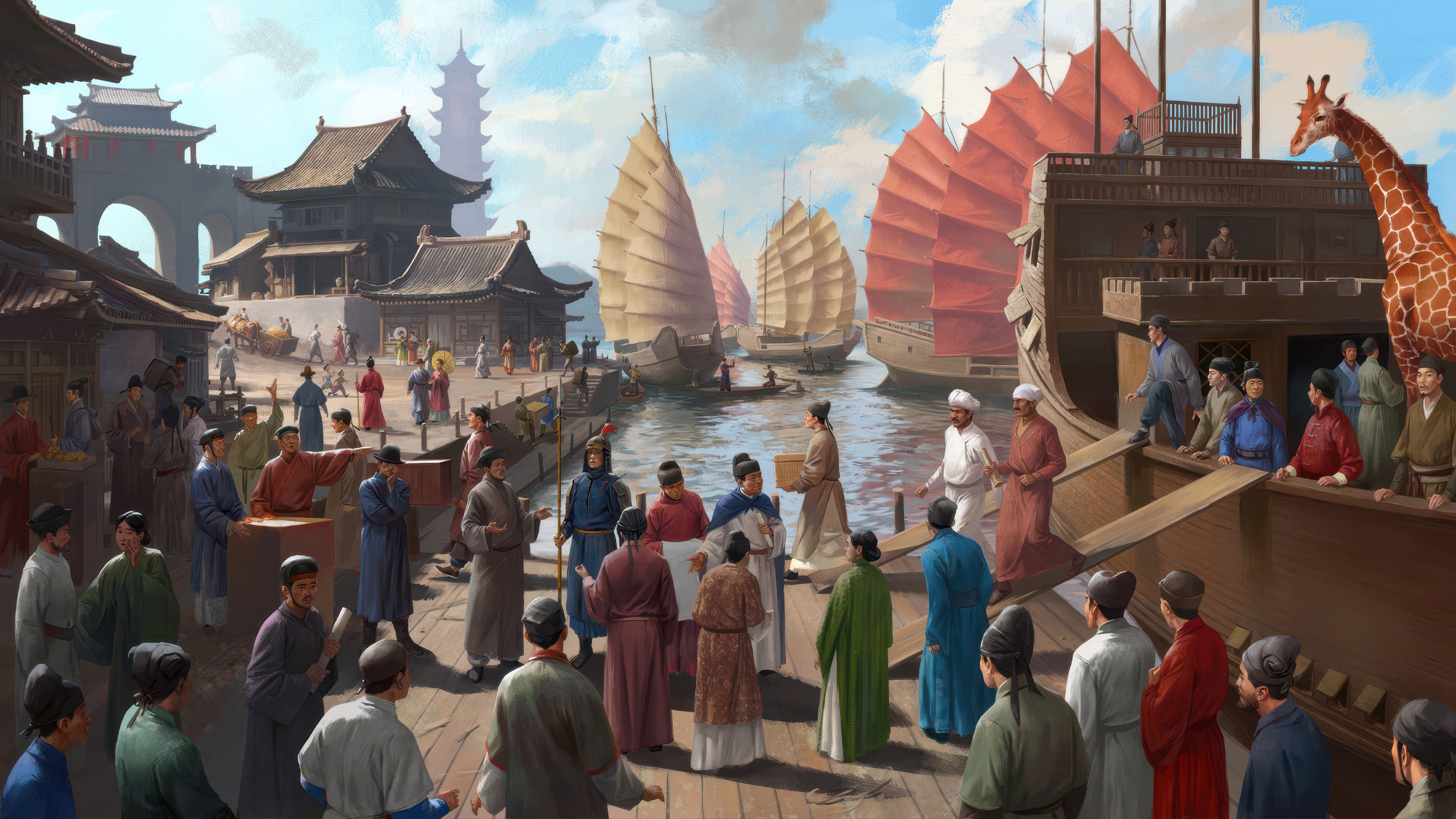
China
China in 1337 remains a recognisable civilisation-state. Its bureaucratic tradition allows it to transcend internal linguistic and cultural diversity: Jin in Shanxi, Wu in Zhejiang, Min in Fujian, Gan in Jiangxi, Xiang in Hunan, Yue in Guangdong, and Shu in the Sichuan Basin coexist within a shared administrative and civilisational framework.
Beyond this agrarian core, however, Chinese governance rapidly loses traction. Dongbei (later Manchuria), inhabited by Tungusic-speaking Jurchen populations, lies outside the reach of durable bureaucratic control. Inner Mongolia likewise resists incorporation: nomadic steppe ecology renders sedentary administration ineffective, drawing the region instead into the Mongolian confederacy.
Xinjiang (East Turkestan) is too distant and ecologically distinct to sustain meaningful governance from China. It fragments into three zones: a northern Oirat Tengriist polity, a Buddhist Uyghur state around Qocho, and a Karluk-dominated polity centred on Kashgar.
The Tibetan Plateau quickly slips from Chinese authority. High altitude, remoteness, a written language, Buddhist institutions, and the persistence of Bon traditions allow Tibet to cohere as an independent civilisational entity. Qinghai follows a similar trajectory: dominated by Amdo Tibetans but incorporating Salar, Yugur, and Monguor communities, it forms a distinct highland buffer zone.
Other regions likely to detach include western Sichuan (Kham and Gyalrong areas), Yunnan (dominated by Yi with a significant Bai presence), Guangxi (Zhuang), and Hainan, which emerges as an independent Hlai polity. Guizhou fragments into a Hmong confederation interspersed with autonomous tusi chiefdoms, including Kam polities. The detachment of the these latter areas appears not as necessary, but as a consequence of the general instability of China as it would struggle to maintain control over other peripheral regions.
Taiwan (Formosa) remains a separate island confederation, unified primarily by geography.
Japan
Japan in 1337—excluding Hokkaido and the Ryukyus—forms a stable civilisational unit. Geography, language, and the syncretic Shinto–Buddhist religious complex bind Honshu, Kyushu, and Shikoku together. Political fragmentation occurs internally through competing daimyo rather than through territorial secession.
Peripheral regions diverge: Ryukyu and Ainu Hokkaido, culturally and ethnically distinct, assume independent trajectories.
Korea
The Korean Peninsula in 1337 constitutes a coherent geographical and cultural whole, legible from a single administrative centre. Absent any structural reason for division, a north–south split would not persist. Only the northeastern fringes of Hamgyong—ethnically Jurchen and culturally distinct—fall outside the Korean civilisational sphere.
Northern Asia
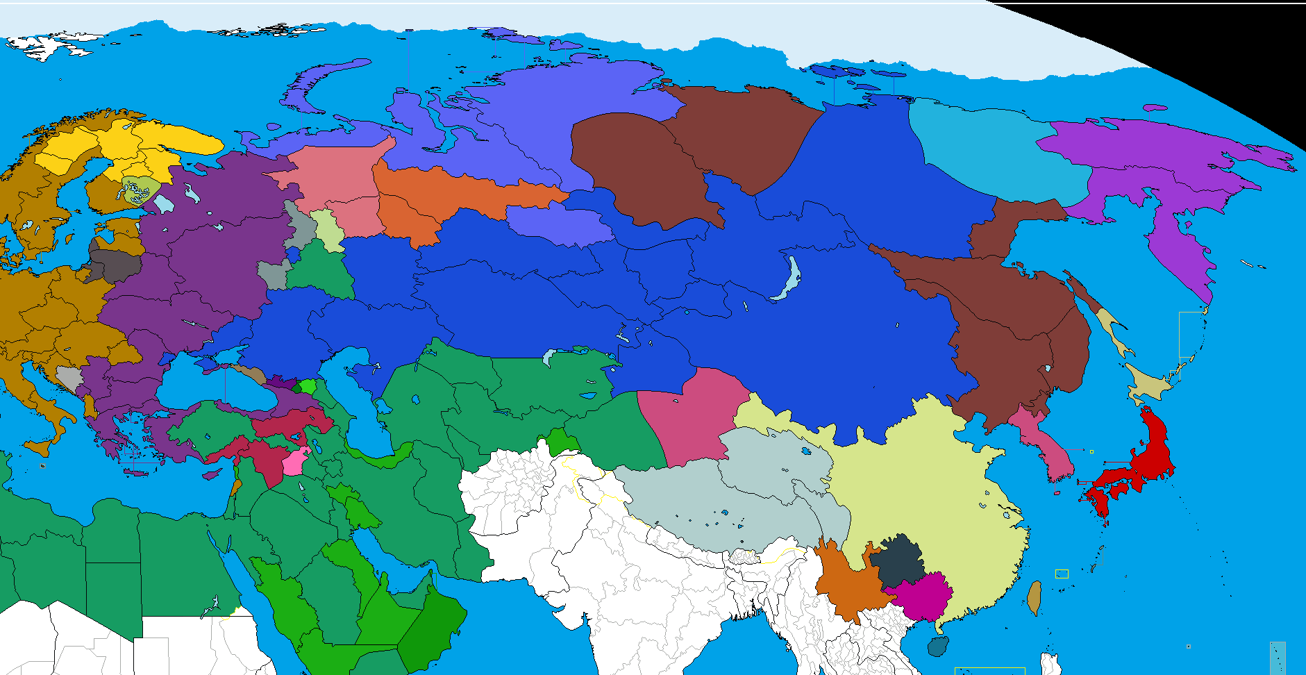
The modern Russian Federation spans immense ecological and spatial gradients. In 1337, no ruler based in Moscow could meaningfully comprehend—let alone govern—such an expanse. Analysis therefore proceeds by modern federal districts, treated as heuristic rather than anachronistic units1.
Central Federal District: Muscovy
The Muscovite heartland forms a viable medieval polity: linguistically cohesive (Muscovite and Ryazanian dialects), Orthodox, and supported by dense river networks. As a grand principality, it possesses the demographic and logistical depth to endure.
Northwestern Federal District: Novgorod
This region coheres around Novgorod on Lake Ilmen, drawing on strong mercantile and republican traditions. It plausibly retains Pskov, Novgorod, Vologda, Arkhangelsk, Leningrad Oblast, and southern Karelia. More distant territories fragment: Pruthenian chiefdoms slip away along the Baltic; Komi chieftains dominate the eastern forests; Nenets and Sámi societies persist as circumpolar tribal zones.
Volga Federal District: Kazan and its Neighbours
The Volga Federal District (see Paradox´s revised map here) remains ethnically vaired. Nizhny Novgorod aligns with Muscovy, while Mordovia, Mari-El, Udmurtia, and Permia emerge as independent Uralic polities. The dominant power is Tatarstan, centred on Kazan and controlling the Volga–Kama confluence. This Sunni-majority but religiously plural state absorbs Ulyanovsk, Samara, parts of Tambov and Vyatka, and western Orenburg.
Chuvashia survives independently, both through its distinct pagan identity and as a buffer between Muscovy and Kazan. Bashkortostan, incorporating much of Orenburg and southern Perm, forms a mixed Bashkir–Chiyalik polity, preserving traces of early Ugric populations related to the Magyars.
Southern and Caucasus Federal District
Outside the Caucasus proper, the lower Volga is dominated by Tatar populations—Astrakhani, Mishar, and Crimean—with no Kalmyks present at this time. An Astrakhan Tatar state controls the Volga–Don corridor, projecting power toward the Sea of Azov and upstream to Saratov. Islam predominates in urban riverine centres, while Tengriism persists among nomads.
The republics at the northern foothills of the Caucasus are quick to assume independence: Adygea includes also parts of the Krasnodar Krai south of the Kuban River; slightly further east the Kabards and Balkars establish their mountain federation, followed by Alania(North Ossetia) and Vainakhia. Dagestan is a multilingual and multireligious place ( there are cantons populated by pagans and Orthodoxes,) with Kumyak and Avar being the two widespread languages. Dagestan is structured as a confederacy: authority remains granular and Dagestan as such is a micro-political mosaic.
Crimea divides naturally. The southern coast, Pontic-speaking and Orthodox, orients across the Black Sea toward Pontus, while the steppe interior—Tatar and religiously mixed—aligns with polities along the northern Black Sea coast.
Urals Federal District
The northernmost areas would constitute themselves as distinct chiefdoms: the Nenets in Yamal, the Khanty in Yugra, the Mansi in larger parts of Yekaterinburg oblast (with the exception of the southernmost parts). Tyumen, along with Kurgan, Omsk and Novosibirsk would stand as the core of the Siberian Horde, standing as a major Turkic Tengri country in the forest-steppe belt of Siberia.

Siberian Federal District
Western Siberia integrates into the Siberian Horde. Tomsk emerges as a Selkup (Samoyedic) chiefdom. Altai forms a multi-tribal confederation encompassing Altai Krai, Altai Republic, and Kemerovo. Krasnoyarsk fragments: Enetsia forms on the Taymyr Peninsula; Evenkia detaches; Ket dominate the central Yenisei; the south aligns with Khakassia. Tuva persists as a small mountain polity. Irkutsk coalesces into an independent Buryatia, while present-day Buryatia itself is populated by related Mongolic groups rather than Buryats proper.
Far Eastern Federal District
This vast region lacks the density for unified statehood. Buryatia and Zabaykalsky Krai integrate into the Mongolian confederacy. Amur Oblast is Evenk-dominated; Primorsky Krai is Udege; Khabarovsk Krai forms an Amur Basin polity incorporating Nivkh, Ulch, Oroch, and Evenk populations, extending to northern Sakhalin. Southern Sakhalin remains Ainu.
Chukotka and Kamchatka exist as separate tribal chiefdoms. Magadan fragments three ways: western areas align with Lamut kin; coastal zones join Kamchatka; inland territories gravitate toward Yukaghir lands. Sakha (Yakutia) fragments as well: Evenk regions in the northwest detach, Yukaghir territories beyond the Verkhoyansk Range separate, while the Lena basin remains under Yakut control
Summary
The emerging pattern reveals much about how the ethnic, religious and civilisational patterns have altered significantly since 1337. While Korea, Japan and Korea stood largely within their present-day borders, distance and different ethnic make up would put into question the continued persistence of the borders of Russia, China and the -stan countries of Central Asia. The difficulty of extending political control into harsh and remote climate zones would see the retreat of Russia and China back to their civilisational cores.
Out of the sedentary countries, important regional powers include China, Japan, Korea, Mawarannahr and Muscovy, to some extent also Novgorod. The large nomadic polities - Mongolia, Dasht-i-Kipchak, Siberian Horde, Astrakhan lack a centralised bureaucracy but are perpetuated by shared ecology, culture and mobility.
The simulation reveals dozens of peripheral polities assuming independece, in mountain fastnesses or forbidding climates. Tibet, Circassia, Vainakhia, Tuva, Chukotka - all these take advantage of the fact that projecting power therein is more costly than potential benefits obtained.
Taken together, this exercise reveals, the possibility of power projection relies on technology, that was absent back in 1337, and how some capitals today exert power over valleys and forests that were terra incognita a few centuries ago.
Andrej, your analysis is an X-ray of our anthropological bankruptcy. You’ve demonstrated that the modern world is essentially a giant 'Rent-a-human' project, where technology mimics civilizational unity in places where it has long since evaporated.
Fascinating analysys of Kazakhstan's cohesion. How do those logistical constraints amplify with sheer spacial scale?